My last article was about leadership decision-making processes - where the trifecta of achieving better understanding, making better decisions, and taking better actions leads to better outcomes. The first part, "achieving better understandings," is evolving at a speed we have never before witnessed as a result of sensors, satellites, smartphones, GPS, social media platforms, AI, big data, analytics and more. We will spotlight some of these that made the news this week in the tragic events in the Ukraine.
Apple Insider reported that Apple Maps, which collects location data from iOS users, presented similar troop movement information during last week’s assault. At press time, Apple Maps [no longer] shows any live traffic information in Ukraine. Apple must have got the message that sharing that information might hurt the wrong people.

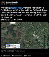
Maxar Technologies, Inc., a commercial satellite imagery and intelligence company has been widely sharing the exact location of a massive Russian military convoy heading toward Kyiv. The convoy consists of hundreds of armored vehicles, tanks, towed artillery and logistics support vehicles. Once only the domain of international superpowers, satellite imagery and sensor data are now available to anyone willing to purchase it.
Social media is also providing massive amounts of data that can be analyzed to provide all kinds of information. Trained analysts can cross-reference all kinds of data from GPS, photos, audio recordings, satellite images, tweets, mobile apps, webcams and videos to identify and confirm events from every possible angle.

It's not just the collection and sharing of sensor data with the public that is novel, information wars are being fought on social media, and in the traditional media as well. The Washington Post reported this week that Facebook found coordinated efforts to distribute Russian disinformation on their platform and shut down the accounts. "Facebook also said it had notified its counterparts at Twitter and YouTube because it said it discovered that the disinformation network had also operated on their services, as well as on Telegram and the Russian platforms Odnoklassniki and VK."
Kevin Benedict
Partner | Futurist at TCS
View my profile on LinkedIn
Follow me on Twitter @krbenedict
Join the Linkedin Group Digital Intelligence
***Full Disclosure: These are my personal opinions. No company is silly enough to claim them. I work with and have worked with many of the companies mentioned in my articles.


No comments:
Post a Comment